

The Klencke Atlas at the British Library (courtesy British Library)
The 1660 Klencke Atlas is among the world’s biggest books, measuring nearly six feet by seven and a half feet when open. So when the British Library digitized the towering tome, it required several people to maneuver it to a platform for its high-resolution photographs.
“We digitized the atlas in order to increase access to the 41 maps which are contained in it, which are extremely rare — some known in only three surviving copies — but not terribly well known,” Tom Harper, lead curator of antiquarian maps at the library, told Hyperallergic. “Obviously the atlas is rather a tricky thing to read — though it has wheels fixed onto it to make it easier to move around! Making the maps available free online enables researchers to study these miracles of Dutch cartography and increase our knowledge of the High Renaissance and beginnings of the scientific revolution in the 17th century.”
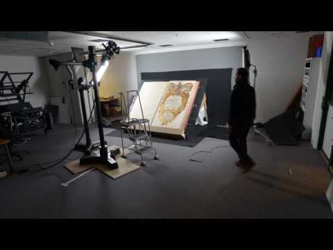
You can watch a timelapse of the multi-day digitization, supported by Daniel Crouch Rare Books, in the video above, recently shared by the library on Twitter. The maps in the centuries-old manuscript were designed to be displayed on the wall, so most other examples deteriorated over time due to exposure and use. The public domain images of the atlas are part of the library’s Picturing Places online resource, launched this month and concentrating on hundreds of landscape-related objects.
“The Klencke Atlas is the British Library map collection’s jewel in the crown,” Harper stated. “It was made for Charles II and presented to him in celebration of his restoration to the throne of England — in May 1660, following the English Civil War and Commonwealth. It was presented by the Dutch sugar merchant Johannes Klencke who possibly hoped to win trading concessions in England; there’s a map of the Dutch colony in Brazil in the atlas, where the sugar plantations were based.”
Harper shared more details of the atlas’s history in an article for Picturing Places, noting that its “scale and conception recalled Renaissance ideas relating to the symbolic power of a book which contained the entire world’s knowledge.” In other words, the heft of colossal charts of the King’s dominion, as well as maps of the known world from the East Indies to China, gave the impression of intellectual weight. In Hyperallergic’s previous round-up of huge religious manuscripts, you can see this idea play out through other super-sized books, like a 165-pound 13th-century bible featuring a full-page portrait of the devil.
In 2010, the Klencke Atlas went on public view at the London library for the first time in 350 years, and now its digitized pages are available for the public to freely explore, no heavy lifting necessary.

Pages from the Klencke Atlas (1660) (courtesy British Library)

Pages from the Klencke Atlas (1660) (courtesy British Library)

Pages from the Klencke Atlas (1660) (courtesy British Library)

Pages from the Klencke Atlas (1660) (courtesy British Library)

Pages from the Klencke Atlas (1660) (courtesy British Library)

Pages from the Klencke Atlas (1660) (courtesy British Library)
View the digitized Klencke Atlas online at the British Library.


