Boston Unveils Finalists in Competition to Retrofit City for Rising Waters
Following on the heels of New York, London, and many other urban centers, Boston is the latest city to envision how best to manage the certainty of rising water levels due to global warming.
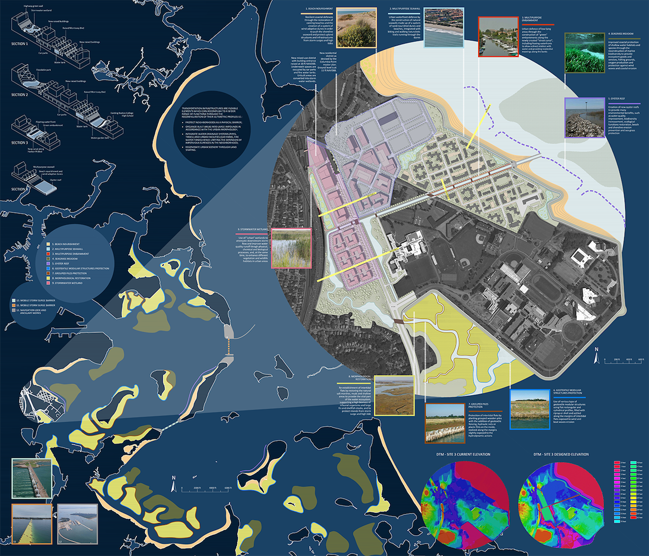
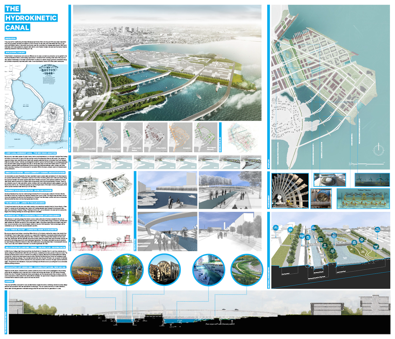
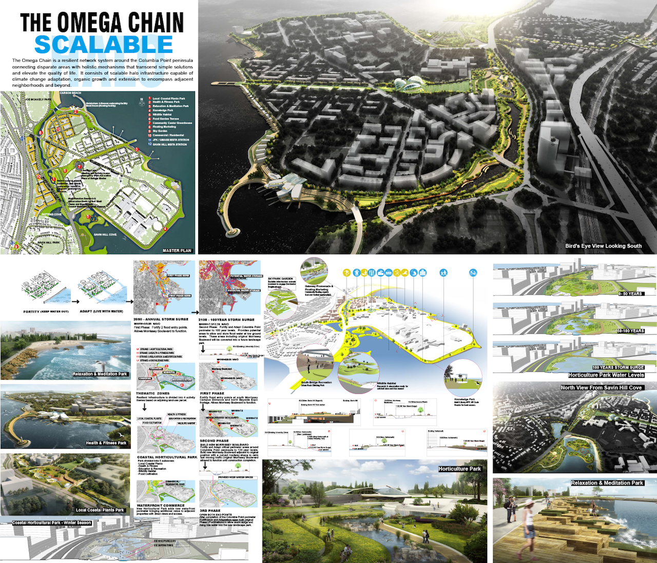
“Total Resilient Approach,” led by Thetis S.p.A., Infrastructure category. This proposal considers the transportation infrastructure as a flexible element aimed at performing a wide range of resilient functions. Raising Morrissey Boulevard and improving its connections to the adjacent neighborhood present an opportunity to redevelop Columbia Point through an overall strategy based on habitat restoration and sustainable urban landscaping. (all images courtesy of Living with Water) (click to enlarge)
Following on the heels of New York, London, and many other urban centers, Boston is the latest city to envision how best to manage the certainty of rising water levels due to global warming. Last month, Living with Water, a design competition sponsored by a coalition of groups including the City of Boston, The Boston Harbor Association, the Boston Redevelopment Authority, and the Boston Society of Architects, announced 9 finalists from 50 submissions.
New Yorkers may be familiar with former Mayor Bloomberg’s plan “A Stronger, More Resilient New York,” a $19.5 billion proposal developed post–Hurricane Sandy to remedy existing devastation and to prevent future massive infrastructure failure due to climate change. And the Museum of Modern Art’s 2010 architects-in-residence program and resulting exhibition, Rising Currents: Projects for New York’s Waterfront, sought to innovate with the city’s relationship to water in much the same way Boston’s Living with Water hopes to.
Applicants to Living with Water competed in three distinct categories: building, neighborhood, and infrastructure, set as the Prince Building, the Fort Point neighborhood, and Morrissey Boulevard in the Dorchester area, respectively. Three finalists “that best accounted for [a site’s] unique climate conditions, minimized flood damage, and provided a resilient, sustainable solution” were chosen per category; the winning team will receive a $20,000 prize.
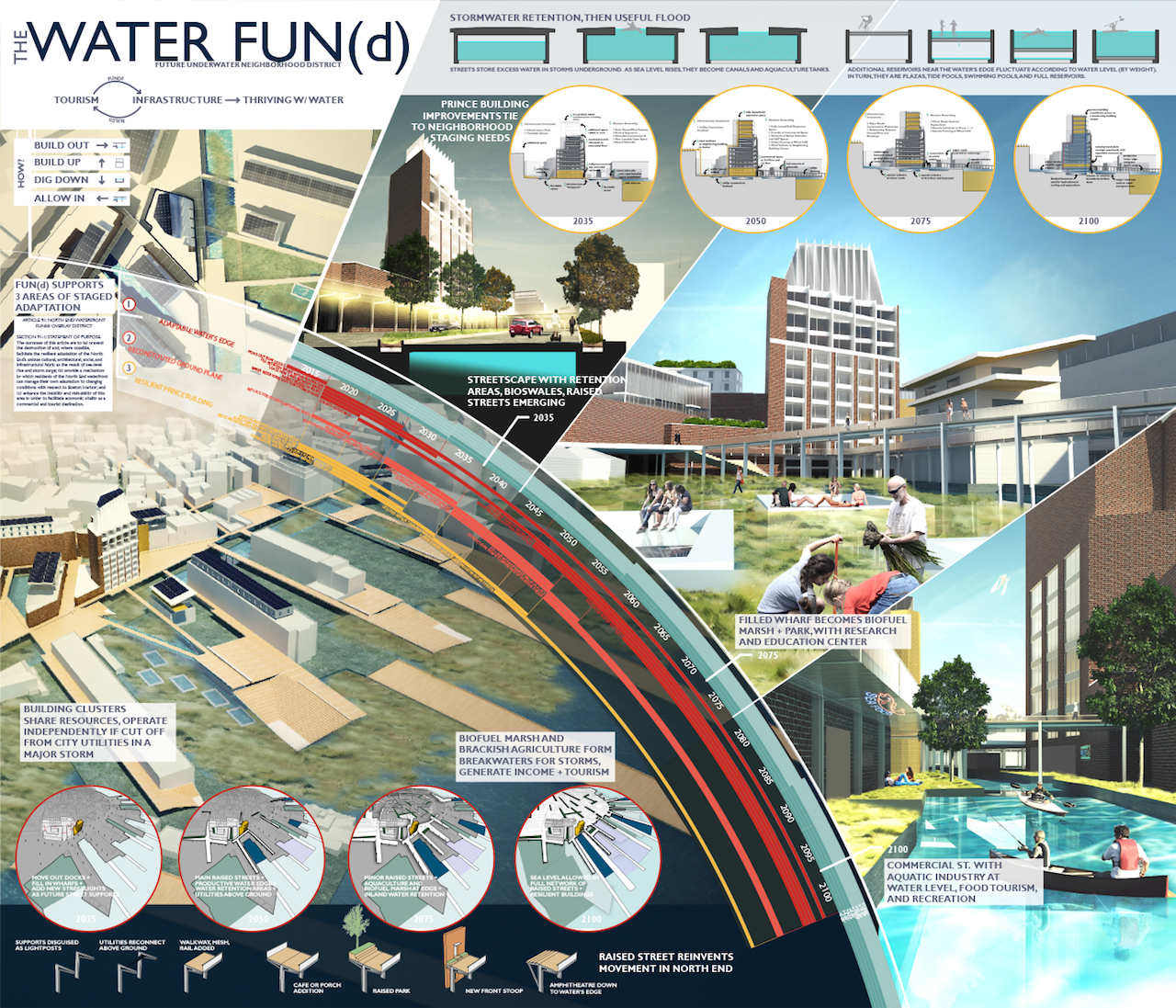
“Water FUN(d),” led by ARC/Architectural Resources Cambridge, Building category. Dubbed the Future Underwater Neighborhood district, or FUN(d), this proposal establishes a goal of creating a new urban area that skillfully interacts with an influx of water on an on-going basis. The team suggests that this plan could be accomplished, at least in part, by drawing on revenue from Boston’s tourism economy. (click to enlarge)
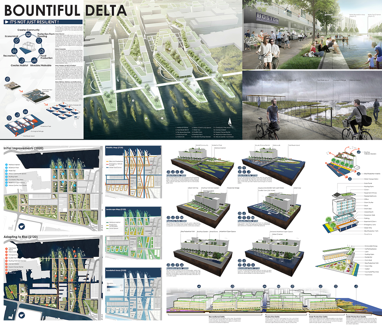
All the plans are essentially optimistic, refusing to cede city territory. Instead, they imagine a future in which rising water levels are incorporated into urban life. For example, in the Water FUN(d) by ARC/Architectural Resources Cambridge, marshlands provide a buffer against flooding while streets are turned into canals that offer boat rides and reroute water. Total Resilient Approach, by Thetis S.p.A., reconstructs the area around Morissey Boulevard using sand dunes, wetlands, salt marshes, oyster reefs, and a number of other bio-tools, in the hopes that bioengineering will create an area able to continuously absorb and adapt to influxes of water.
In a similarly rosy tone, Boston Mayor Martin J. Walsh commented: “It’s difficult to imagine what the world will look like in the year 2100, but we know for certain that now is the time to prepare for sea level rise. The proposals that came in from around the world demonstrate that a more resilient, sustainable, and beautiful future is within our reach if we work together.”
This positivity is admirable, but the problem is that it paints severe climate change as a design problem of the future, rather than a current threat to life on the planet as we know it. Extreme weather, food shortages, and increasing pandemics are all likely byproducts of a world in which global warming proceeds at its current rate. To imagine a future in which we row around in gondola-filled canals is pleasant, but also naïve (it’s not like Venice is faring well with rising sea levels), and at worst it detracts from the urgency of implementing measures to try and halt climate change as much and as quickly as possible.
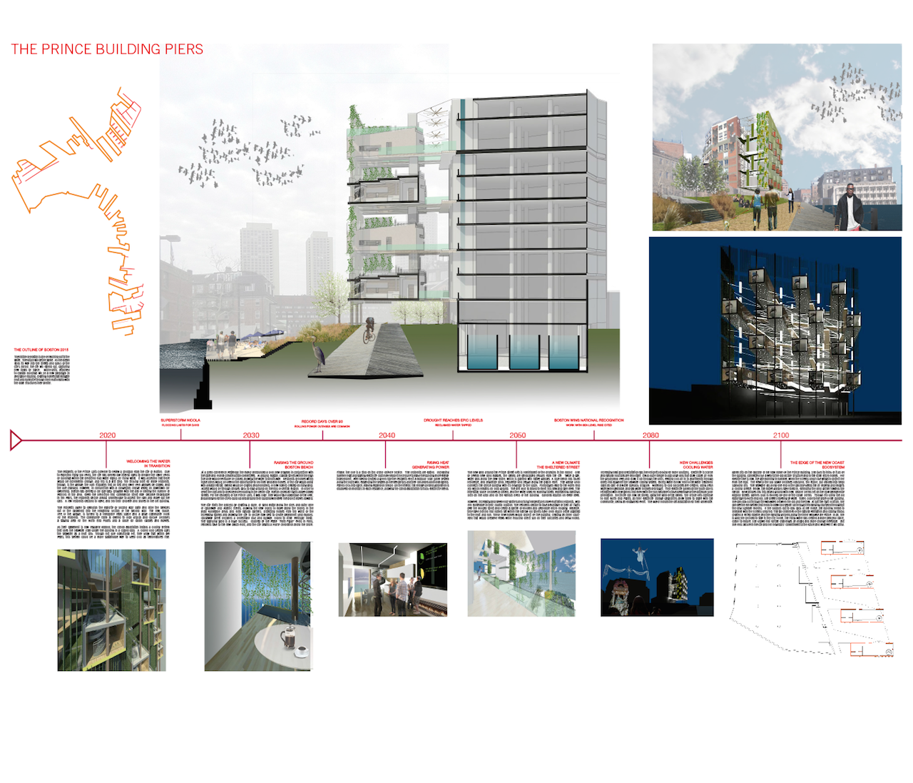
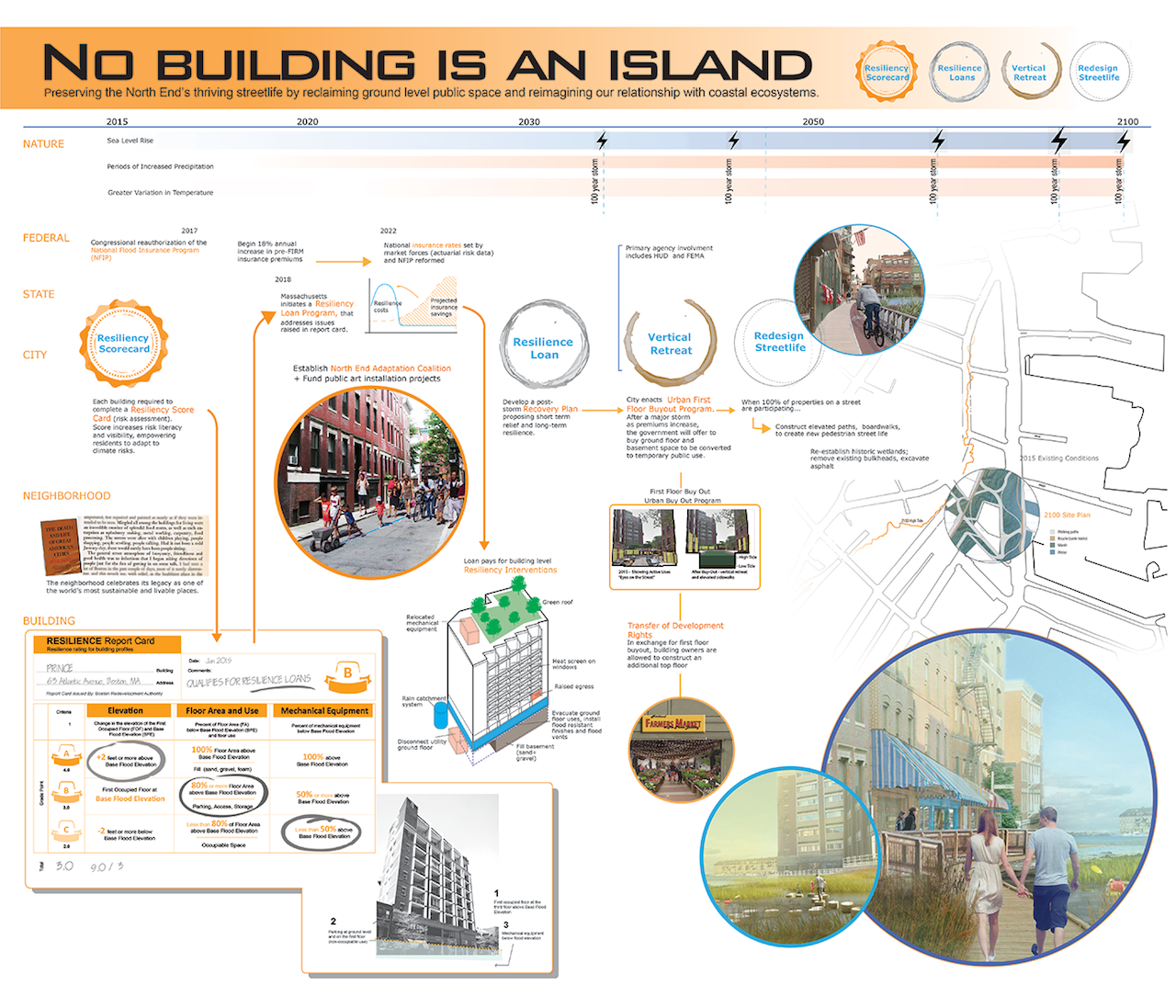
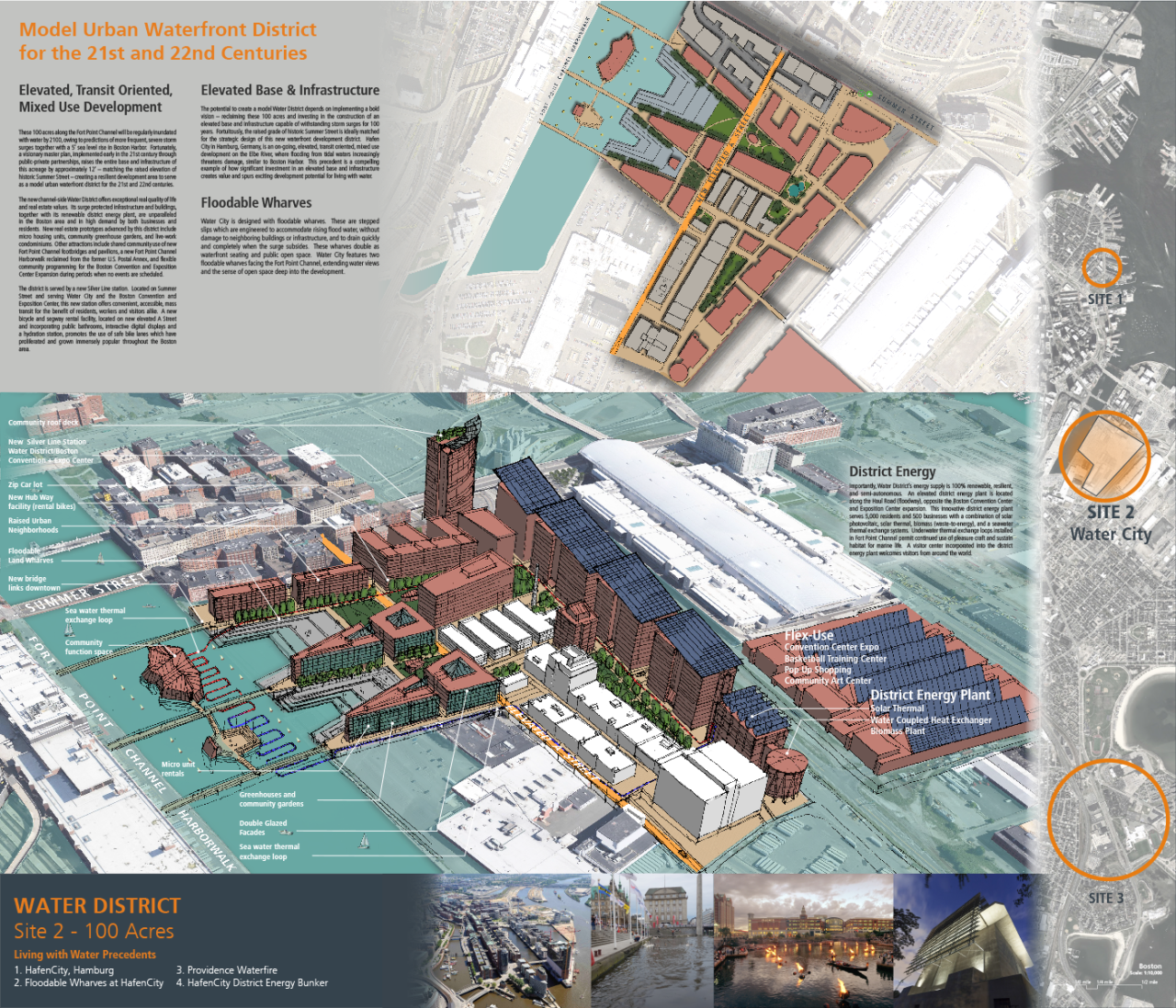
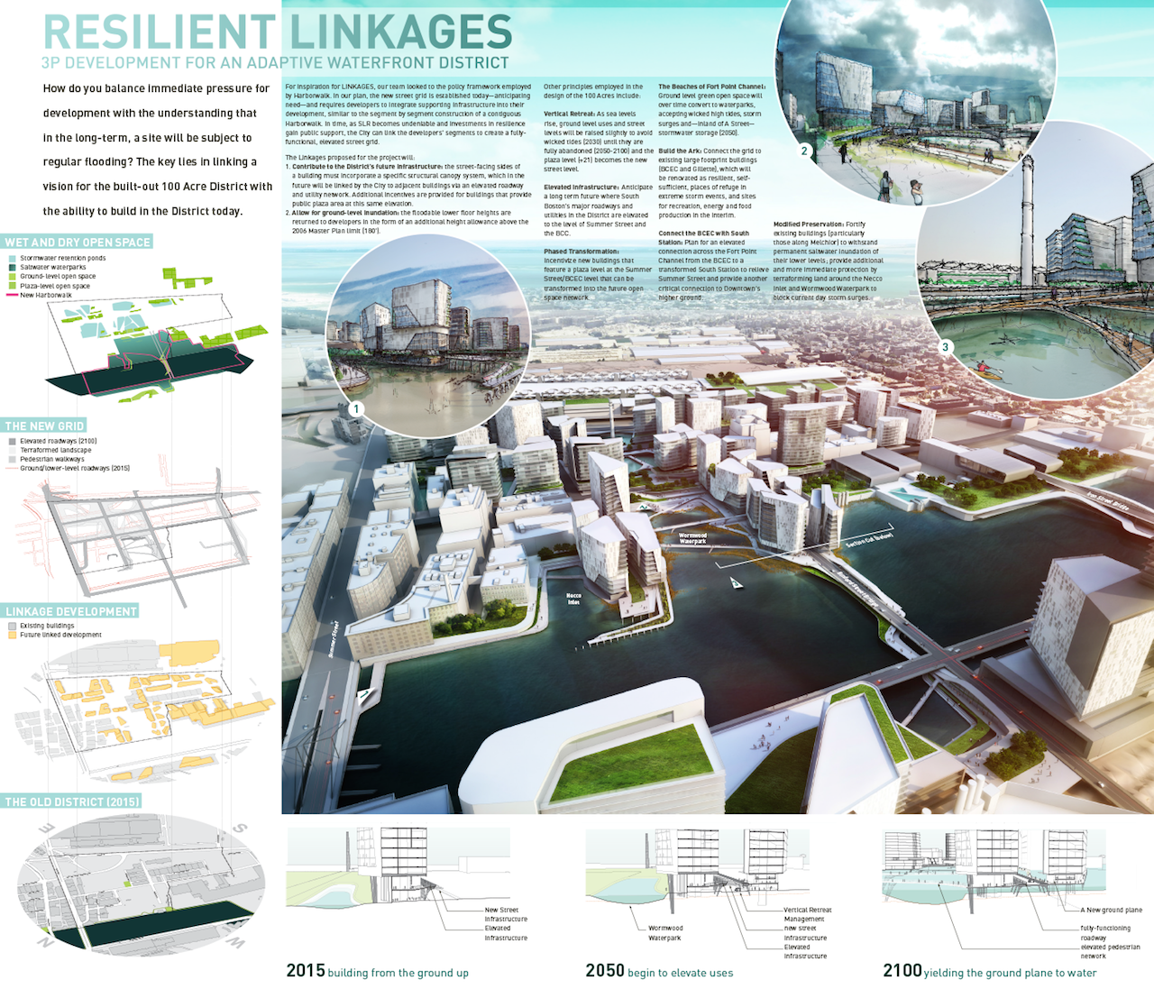
“The Prince Building Piers,” led by Stephanie Goldberg AIA and Mark Reed AIA, Building category. Rather than trying to prevent seawater from entering the city, this proposal welcomes the water and surrenders the outer streetscapes to a new urban seashore that is a focus of recreation, ecological reclamation, and new cultural experiences. (click to enlarge)“No Building is an Island,” led by Harvard Graduate School of Design, Building category. One of the most creative aspects of this proposal is the Resilience Report Card, a simple, user-friendly method that would indicates a building’s vulnerability and allow the city to map risk and target investments. (click to enlarge)“Model Urban Waterfront District,” led by Architerra Inc., Neighborhood category. This proposal would raise the entire base and infrastructure of the 100-acre neighborhood by approximately twelve feet, matching the raised elevation of historic Summer Street and creating a resilient development area to serve as a model urban waterfront district for the 21st and 22nd centuries. (click to enlarge)“Resilient Linkages,” led by NBBJ, Neighborhood category. This proposal attempts to balance the immediate pressure for development in Fort Point with the long-term understanding that the area will be prone to regular flooding in the future. The plan would establish a new, elevated street grid and require developers to integrate supportive infrastructure for sea level rise into their projects, which could then be linked to form fully-functional, neighborhood-scale infrastructure. (click to enlarge)“Bountiful Delta,” led by University of Washington, Neighborhood category. Guided by the notion that resilience alone is not good enough, this proposal envisions waterfront neighborhoods that “are not just persistent but prosperous.” The strategy calls for modular infrastructure, adaptable land (think of a community garden that could be transformed for fish farming), a lively and water-resilient pedestrian streetscape, and community spaces, restaurants, and retail establishments to provide a genuine neighborhood feel. (click to enlarge)“The Hydrokinetic Canal,” led by Paul Lukez Architecture, Infrastructure category. This proposal for transforming Morrissey Boulevard and Harbor Point over the next 100 years draws inspiration from the topographic and land-use patterns of 17th century Boston. A new system of waterways would be created to increase Columbia Point’s resilience to climate change, generate sustainable energy, and provide an expanded, improved public realm. A new Hydrokinetic Canal is this urban plan’s centerpiece. (click to enlarge)“The Omega Chain,” led by Howard & Cavaluzzi Architects Int. LLC, Beijing Office, Infrastructure category. The Omega Chain would be a resilient network system around the Columbia Point peninsula that connects disparate areas with holistic mechanisms that transcend simple solutions and elevate quality of life for residents. It contemplates gradually converting the existing Morrissey Boulevard into a landscaped park and constructing a new elevated and curved roadway adjacent to the park to calm fast-moving traffic. (click to enlarge)