The First Comprehensive Map of Karakorum, Capital of the Mongol Empire
Until now, descriptions of the city were mostly limited to the written accounts of European explorers, says a new study in the journal Antiquity.

In a significant milestone for the study and understanding of the Mongol Empire, archaeologists have mapped its capital of Karakorum. Physical traces of the ancient city, founded in the thirteenth century, are still visible to this day in the Orkhon Valley of central Mongolia. But little archeological research has been carried out at the site, and until now, descriptions of the capital have been mostly limited to the written accounts of European explorers,says a paper published last week in the academic journal Antiquity.
"Most historians and archaeologists have simply accepted these observations at face value, and no previous research has been undertaken to add detail to this picture by locating the different quarters, elite residences and other areas, or to understand how the city developed over its 200-year existence," the authors write.
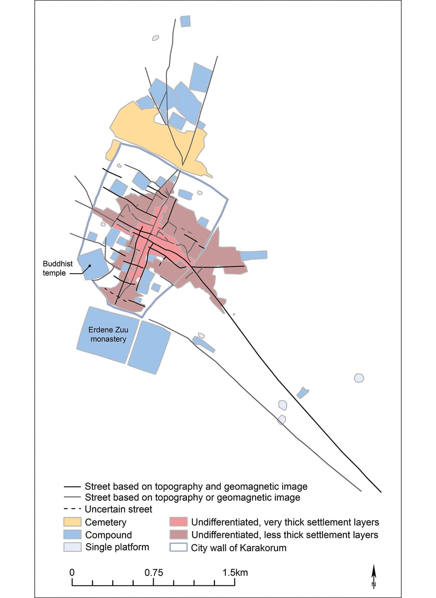
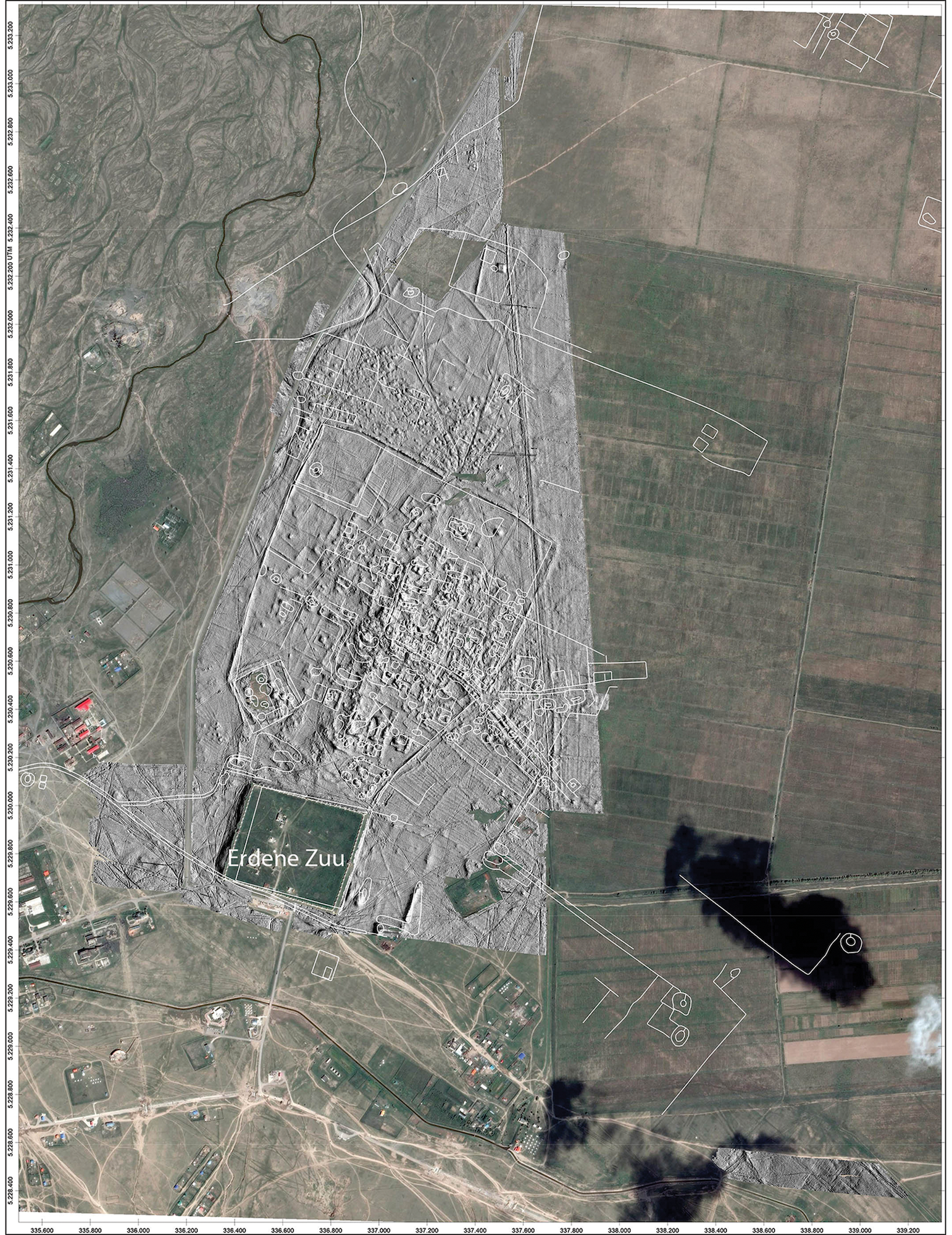
An international group of researchers led by Jan Bemmann, principal investigator in the Institute of Archaeology and Anthropology at the University of Bonn, spent nearly two months surveying the walled city and its surrounding landscape using a SQUID (Superconducting Quantum Interference Device). The instrument, which measures the topography of the surface as well as the magnetic fields of the ground below it, was applied to an area of 465 hectares, revealing the city "in unprecedented detail."Bemmann and his team combined the SQUID's findings with aerial photographs and existing records, such as an early map of the capital drawn by Wilhelm Radloff in 1892, to produce a comprehensive view ofKarakorum's layout, size, and organization, including its road networks and the first-ever breakdown of its neighborhoods and structures. Along a road to the west, the survey revealed large, concave forms that likely represented walls of collapsedcompounds made of sun-dried mud bricks.
An analysis of the data resulted in several "novel insights," the study's authors report. Perhaps most significantly, they discovered that the ancient capital stretched far beyond the areas documented so far — it had no clear limits, and continued more than three kilometers (~1.8 miles) past the city walls. Surprisingly, however, as summarized in a tweet by Antiquity, the "biggest single feature ofKarakorum was nothing": about 40% of the area within the walls was left empty. This may reflect the nature of the Mongol Empire's inhabitants, primarilypastoral nomads who did not typically need to build permanent residences; certain areas were likely keptunderdeveloped deliberately to provide space for temporary, mobile dwellings.
"The peculiarity of these cities lies in the fact that they were ‘implanted’ by the ruler into a landscape without fixed architecture, and that the permanent inhabitants were brought from abroad," the authors write. "Our current understanding suggests that the city of Karakorum and its inhabitants arrived fully formed."
Founded by Genghis Khan in 1206 CE, the Mongol Empire was at its height the largest contiguous land empire in history.Karakorum was established as its capital by his son, Ögedei, in the 1230s, who set up a royal palace there and transformed the settlement into a commercial hub. He chose the site where Genghis Khan had strategically set up a camp of yurtson a major east-west route across Mongolia on the Orkhon River valley, considered a sacred homeland by the nomadic steppe peoples. Karakorum became one of the most important cities of the Silk Road.
Bemmann and his team believe their research will pave the way for further, targeted excavations and non-destructive surveys of the capital.
"The combination of large-scale and high-resolution surveys now undertaken reveals that the city had no clear limits, with built areas becoming less dense with distance from its centre," they write. "Moving forward, the highly variable thickness of the settlement layers must be evaluated critically in relation to population density, duration of use and types of activity."