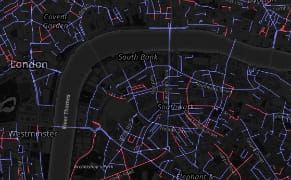
This August, activist group Osez le Féminisme (Dare to be Feminist) installed guerrilla signs in Paris to rename streets and parks after women like singer Nina Simone, sailor Florence Arthaud, and author Simone de Beauvoir.
Mapping
Two New Data-Mapping Tools Help Us Better Understand the Planet
Two recently launched applications for mapping datasets examine our planet and humanity’s impact on it.
Mapping 13 Centuries of English Metaphors
A three-year project from the University of Glasgow’s School of Critical Studies mapped 13 centuries of metaphors in the English language.
New York’s Oldest Museums: Where Are They Now?
Old NYC, a project by software engineer Dan Vanderkam, launched last month with thousands of images from the New York Public Library mapped across the five boroughs.
Open Source Software to Catalogue Cultural Heritage Before a Crisis
Cultural heritage management tends to suffer from limited funding and resources, which can make a crisis — whether natural disaster, pipeline construction, or war — that much more catastrophic for assessing what’s in need of protection.
Open-Source Maps Help Guide Nepalese Earthquake Relief
A crucial need in any rescue effort — perhaps just as important to saving lives as medical supplies, food, and tents — is an up-to-date map that humanitarian workers can use to more efficiently navigate the rubble.
Using Fiction to Map the Emotional Geography of Victorian London
The Stanford Literary Lab has plotted quotes from over 700 19th-century authors who mentioned locations in London in order to compose concentrations of dread or happiness.
Navigating Brooklyn from the 17th to the 21st Centuries
Brooklyn has long touted its status as the unofficial fourth largest city in the United States, if not for the so-called “great mistake of 1898” — the consolidation of New York City.
An Online Design Platform to Make Your City More Walkable
What started as an unsanctioned urban intervention is getting increased official support for bringing grassroots wayfinding to the streets.
Mapping Lunar Beauty
Maps made by the US Geological Survey offer a vastly different visual depiction of the Earth’s moon, using the full color spectrum to denote differences in topography and geology.
Mapping Inca Times in Subterranean Cusco
Peru’s culture ministry has announced a new subterranean mapping initiative that will allow archaeologists to explore pre-Columbian Cusco without picking up any shovels.