Art
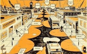
Using Fiction to Map the Emotional Geography of Victorian London
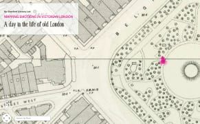
The Stanford Literary Lab has plotted quotes from over 700 19th-century authors who mentioned locations in London in order to compose concentrations of dread or happiness.
Art
The Stanford Literary Lab has plotted quotes from over 700 19th-century authors who mentioned locations in London in order to compose concentrations of dread or happiness.
Art
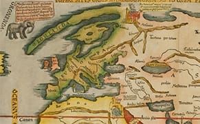
During the late Renaissance, many gold-thirsty European explorers set sail on a quest to locate the fastest route to the Orient.
Art
Considering how long the earth's been around, you'd think it would have already been exhaustively charted. But in recent years, mapmaking has exploded.
Art
Two 1970s photography series that chronicled the urban landscapes of New York City are now accessible on interactive maps through the New York Public Library's ongoing Photo Geographies project.
Art
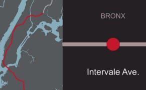
As the 2 train travels from Brooklyn through Manhattan up to the Bronx, it journeys along 49 stations of neighborhoods as varied as Flatbush, the Financial District, and Wakefield.
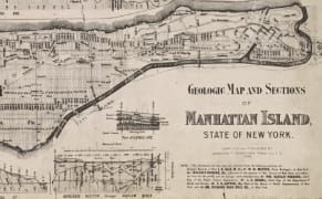
Art
Last year, the City of New York released a huge trove of tax data to the public. Called Property Land Use Tax Lot Output (PLUTO), the information might not seem terribly thrilling, a dry assortment of building dates, square footage, and property value, but for those looking to map the city's history
Art
"There are so many sounds in museums that we usually ignore that are absolutely engrossing once you take the time to focus on them," says artist John Kannenberg, who's been recording museum noise for 15 years.
Art
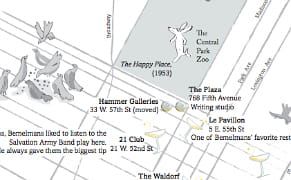
Madeline, the smallest of the "twelve little girls in two straight lines" who lived in "an old house in Paris that was covered in vines," was born in Manhattan. In Pete's Tavern on Irving Place in 1938, Ludwig Bemelmans scrawled those first rhyming lines that would introduce his petite heroine of th
Opinion
The best fiction often succeeds because its creator has constructed a convincing world. By that I don't mean a place that seems realistic, but rather a world that's believable because it's been thought through — pages of notes, characters described down to their beauty marks, the relationships betwe
Art
There was much rejoicing among cartography lovers when the New York Public Library's Lionel Pincus & Princess Firyal Map Division recently released over 20,000 maps for free use.
Art
Back in 1932, a naval historian named Charles O. Paullin and a geographer named John K. Wright published a colossus of cartography called Atlas of the Historical Geography of the United States.
Art
If you want to claim a territory, it's good to have a map to show what's yours. Defining Lines: Cartography in the Age of Empire at the Nasher Museum of Art at Duke University examines how maps were a form of political control and public perception by Western colonial powers from the 16th and 20th c