In the State of Nevada, This Land Is Not Your Land
WENDOVER, UTAH — Land use has got to be one of the least sexy topics of conversation.

WENDOVER, UTAH — Land use has got to be one of the least sexy topics of conversation. It’s not exactly pick-up line or first date material for most people — “So I was reading about the new noncommercial zoning restrictions being considered by the community board last night …” And yet, land use, and the control of apportioning it, is central to many heated conversations and histories in this country, particularly at the present moment — from the preservation of manufacturing jobs to improving the availability of affordable housing and pretty much any conversation about gentrification.
As a current city-dweller who grew up primarily in the suburbs and around military bases (my dad was in the Army), I used to operate under the naïve assumption that zoning was primarily an issue in cities. But while hurtling across vast and largely uninhabited swathes of Nevada and Utah on a road-trip this past summer, I found myself thinking about land use in a much more expansive way.
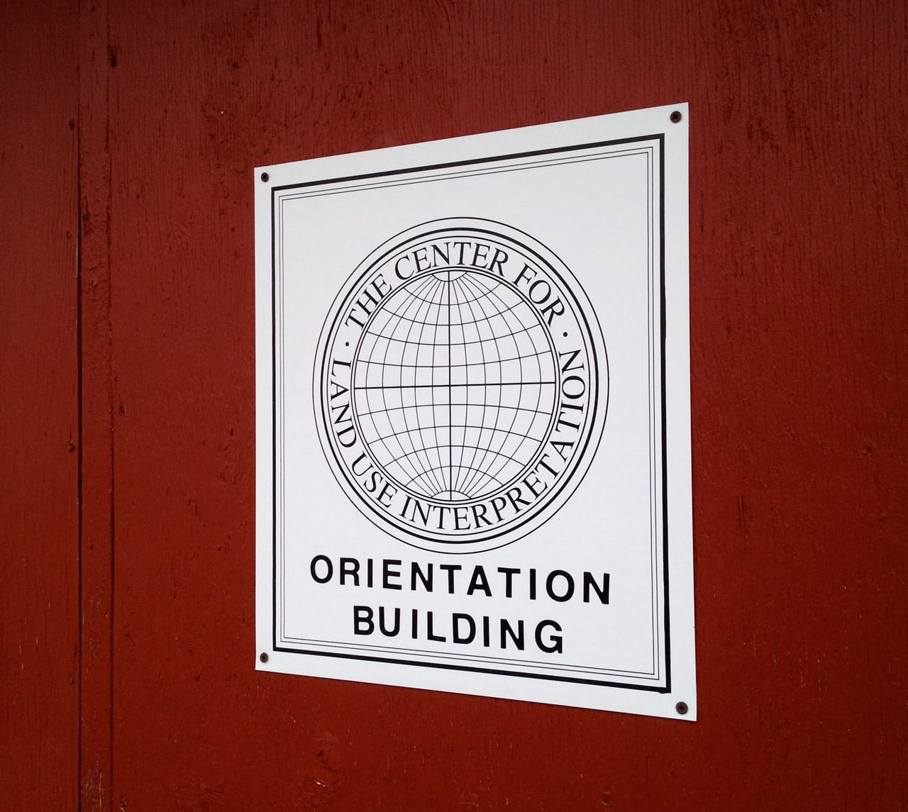
Some of you may already be familiar with the Center for Land Use Interpretation (CLUI). I first came to know about it when I heard a friend was going to be an artist-in-residence at CLUI’s Wendover Complex while I was out on the road. Since we were passing through the area, I decided to make a pit stop.
Stretching across a border, Wendover is situated in both Nevada and Utah, about 120 miles below the northern edge of both states. Most people will experience the town as a handful of casinos on the Nevada side and a smattering of down-and-out motels on the Utah end. But if you’re curious and head south for a few dusty blocks off the main drag, you’ll find the Center for Land Use Interpretation’s Wendover Complex, where a whole different world opens up.
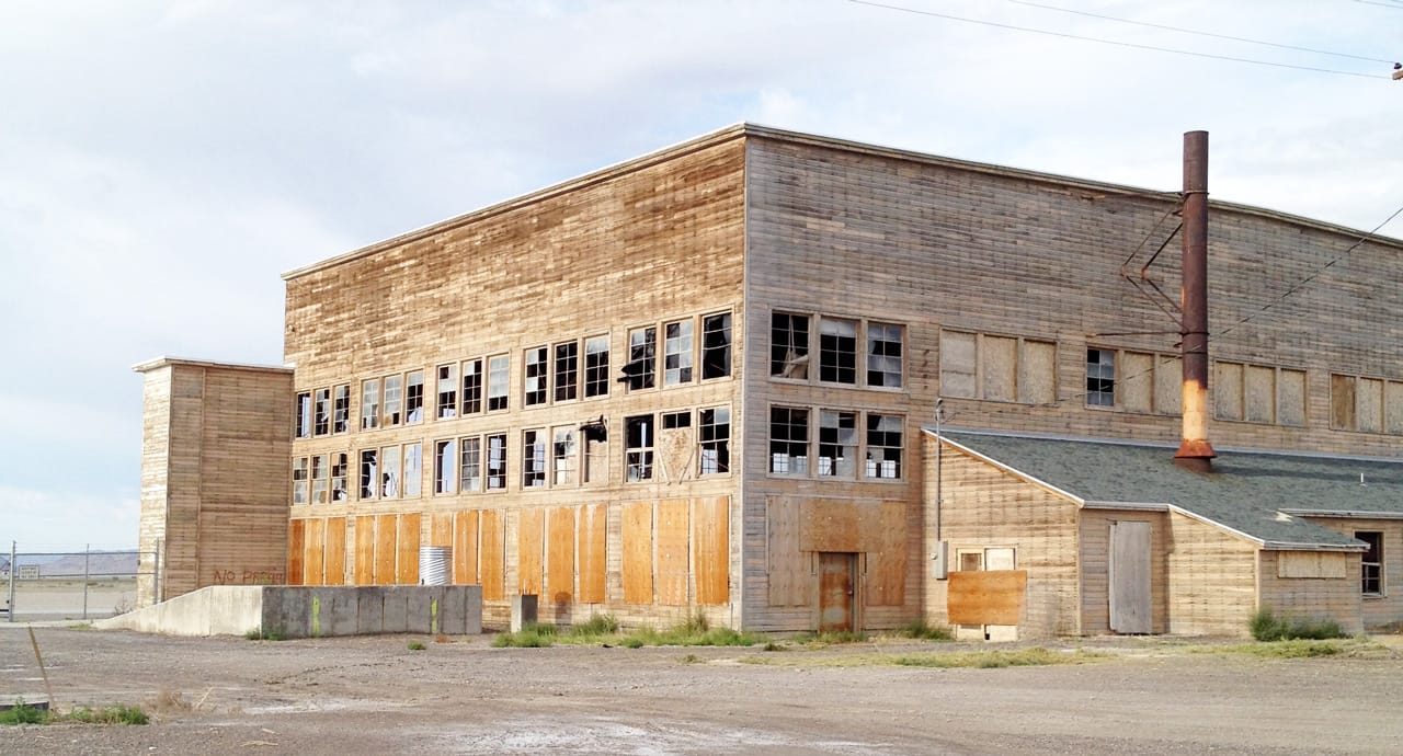
The Wendover Complex is a scattered collection of old buildings, many of them former barracks and most in very rundown condition. The place is a relic of Nevada’s strange history as the US state most used and controlled by the federal government — a tale that can be read through the history of the area’s land use.
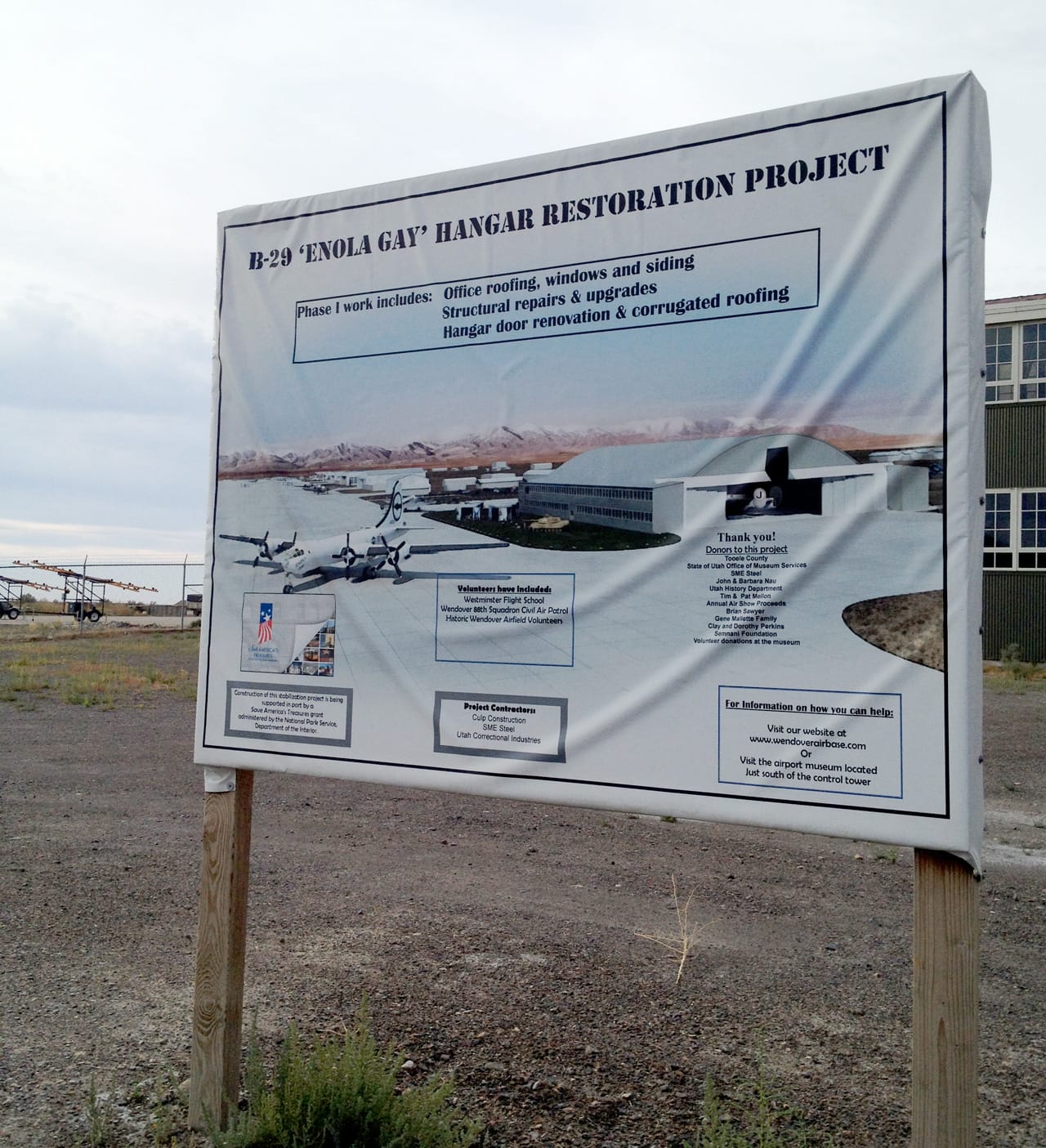
For a few decades, Wendover was one of the largest military installations in the world. Starting in 1940 it jumped from a town of only 103 people to an Army operation with over 20,000 civilian and military employees when the US government claimed close 2 million acres, despite vigorous protests from local ranchers who stood to lose grazing land for their cattle. Soon thereafter the military began testing everything from missiles to bombs to aircraft in the area. And perhaps most famously, it is the place where those involved in the development of the atomic bomb decided to train pilots and crews to drop those bombs. For a short time, the Enola Gay, sat in the largest of the few remaining hangars at the site while its crew trained. This made Wendover one of the last stops for that notorious plane before it flew out to conduct an operation over Hiroshima, Japan, that killed roughly 70,000 people, injured another 70,000, and left radiation effects that would kill at least 100,000 in the immediate aftermath, not to mention the longer-term health and environmental effects.
The Army stopped using the airfield in the 1960s and officially returned most of the land to the City of Wendover in the 1970s. Today, the town’s population fluctuates around 1,500 and what’s left of the airfield and former base are a strange mix of aging buildings, an active civil airport, mixed efforts at historic preservation, military and civil defense, and the CLUI’s art space.
It’s precisely the town’s weird mix of uses, combined with the vastness of the desert and mountain landscape that surround it, not to mention the indigenous and colonial histories of the area, that seem to make it the perfect location for CLUI’s commitment “to the increase and diffusion of knowledge about how the nation’s lands are apportioned, utilized, and perceived.”
Beyond CLUI’s artist-in-residency program, it also hosts art and cultural exhibitions in some of the buildings it has use of at Wendover, including an array of displays focused on land use, such as a map of Nevada revealing that over 85% of the state of Nevada is controlled by the government.
What does it mean that the government controls the land and what are the mechanisms by which it exerts that control? Does anybody have access to the land? And what other groups or purposes are being kept out by those who have figured out a way to maintain their interests there? A lengthy essay in the February issue of Harper’s Magazine describes a group of militia members tied to a wealthy white rancher who are using intimidation and violence to effectively bully the government into letting them exploit and destroy incredibly precarious ecosystems in the high dessert. Last summer a young white couple associated with the group shot two police officers in a Nevada pizzeria at point blank range, then draped their bodies with a flag that read “Don’t Tread on Me.”
This recent violence and the military uses of many parts of Nevada echo some of the historic conflicts that gave birth to treaties that would declare much of North America to be the United States. It also highlights the ways in which fights over land continue to be primarily fights between those with enormous and undue power. The CLUI’s work raises questions about how the realms of art and culture have been affected by the politics of land use and whether they are operating within similar systems.
The bulk of CLUI’s engagement with the arts is specifically focused on land art, the majority of which in North America is located in the South West of the United States. From their headquarters in LA, the CLUI has launched tours of land art sites and mounted small exhibits, such as Formations of Erasure: Earthworks and Entropy, that pose questions about the mechanisms by which land art is realized, particularly work on a grand scale that literally alters the landscape, asking what happens to these works after they are completed.
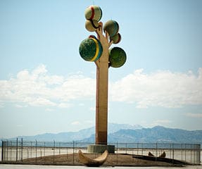
One work in particular seemed to encapsulate for me the ways in which arts, culture, money, land use, and long-term impact collide. After seeing a photo and some text about it at CLUI’s Wendover Complex, I was eager to see it in person. Heading east out of Wendover, it’s one of the first things you notice on the horizon: Karl Momen’s towering 1980s sculpture “Metaphor: The Tree of Utah.” It rises up out of one of the flattest expanses on Earth, just feet away from the mirage-covered Interstate 80. For the past few years the sculpture has been surrounded by razor-topped fencing which is said to be there in an attempt to deter people from pulling over or vandalizing it. Momen has apparently proposed adding a visitor’s center and an exit ramp to the highway in the area, but so far those plans have gone nowhere.
You can read a full, if entirely one-sided, account of its creation here. Momen, a Swedish artist and citizen, used patronage and his own funds to cover the costs of creating the work, which topped $1 million. After discussions with the Utah Arts Council went awry, he befriended and enlisted the help of a wealthy local land owner, Kosro Sumnani, who, in the end, leap-frogged public land use issues by arranging a swap whereby Sumnani gave the local government some of his own land in exchange for the plot upon which the sculpture now stands, so that it would be on private rather than public land.
I found it impossible not to look at that hulking and tiresomely erect thing and feel like it was an absurdly massive symbol of colonialist patriarchy. A wealthy man from Europe comes to Utah, spends little to no time in the area, literally a matter of hours, before deciding that he’s had a vision which he imbues with inherent public value. Then, after overcoming both difficulty and opposition, he pours truckloads of money and resource into its realization. And to top it all off, at the end of the process, he then “gifts” the thing to the State of Utah, now the proud owner of something it never wanted to begin with. Take something that isn’t yours and that you have little personal connection to, steamroll the opposition through money, influence, and/or claims of private ownership, build something enormous that has little to no relationship to its surrounding environment, and then leave it for others to deal with while asking for good favor for having done it: welcome to land use in America!
Momen’s is not the only public art work that made use of large personal fortunes to circumvent local interests. The CLUI website features a post from 2013 about a trip they organized to visit Michael Heizer’s work “Double Negative” in Overton, Nevada — a work comprised of two massive trenches blasted and dug out on either side of a canyon on a 60 acre parcel of land purchased for the artist with money from the art collector and dealer Virginia Dwan. The CLUI trip coincided with the opening of the exhibit Ends of the Earth: Land Art to 1974 at MoCA in LA, and their post about it reveals a series of events that connected Heizer to those with the means to help him, also revealing that the work was made “without permits or engineered drawings.” Thinking about Heizer and Momen’s work through the lens of the money, power, and impact on the land raises some complex questions about the relationship between land use and public art.
Having seen in my own neighborhood in Brooklyn, NY, the way that changes in zoning are tied to jobs, private profit, the loss of affordable housing, and a reduction in public space, I found the CLUI’s work in a very different environment both instructive and challenging. The same questions seem to resonate in highly populated areas as those assumed to be devoid of people — how do you balance the machinery of moneyed privilege that drives much of the cultural sectors’ use and appropriation of land with the growing recognition that without responsible stewardship, communities and ecosystems can be wiped out completely?