The Octopus, a Motif of Evil in Historical Propaganda Maps
Since the 19th century, the motif of an octopus on propaganda maps has represented the inhuman spread of evil, its tentacles grasping for land and power.
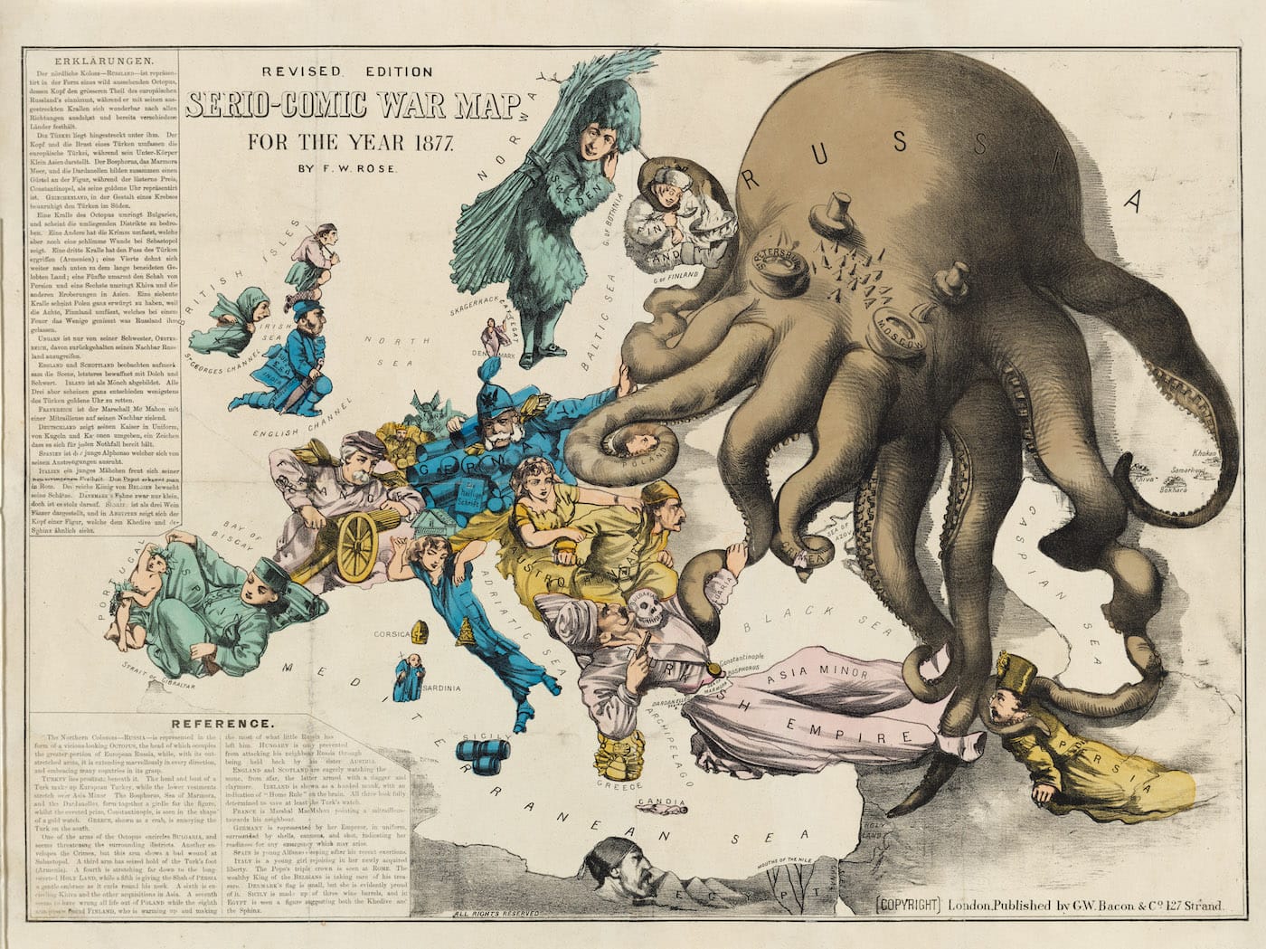
Fred W. Rose, “Serio-Comic War Map For The Year 1877” (1877), published by G. W. Bacon & Co. two months after Russia attacked the Ottoman Empire in response to the Turkish massacre of Christian Bulgarians (represented by a skull) (courtesy Persuasive Maps: PJ Mode Collection, Cornell University Library)
Caricaturist Fred W. Rose’s 1877 map published in the midst of the Russo-Turkish War shows Russia creeping like an octopus across the globe, its tentacles grasping at land on all sides. While the other countries are illustrated as people, Russia is depicted as something alien and monstrous. The arresting visual began a trend of cartographic cephalopods, many of which feature in the PJ Mode Collection at Cornell University Library.
As previously covered on Hyperallergic, the PJ Mode Collection, donated to Cornell in 2014, focuses on “persuasive cartography,” or cartographic propaganda. These maps from the 15th century to the present were designed to convey a certain point of view rather than an accurate geography. Last month, around 500 maps were added to the online collection, doubling the number of available images and descriptions. Rose’s map is among these additions, along with other graphics that employ the octopus.
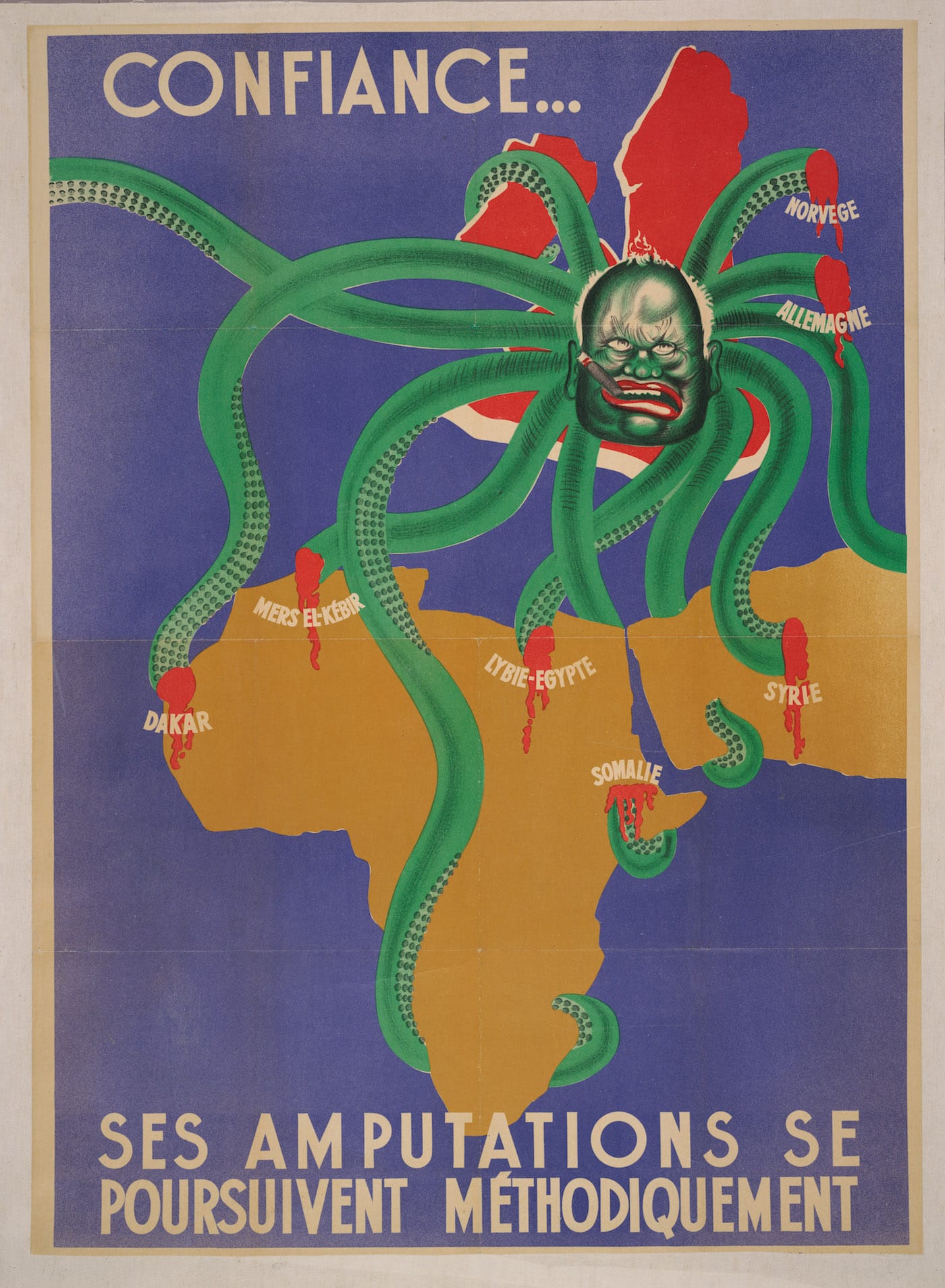
S.P.K., “Confiance – ses amputations se poursuivent méthodiquement [Have Faith – The Systematic Amputations Are Continuing]” (1942), a propaganda poster from German-occupied France showing Winston Churchill as a giant octopus smoking a cigar (courtesy Persuasive Maps: PJ Mode Collection, Cornell University Library)
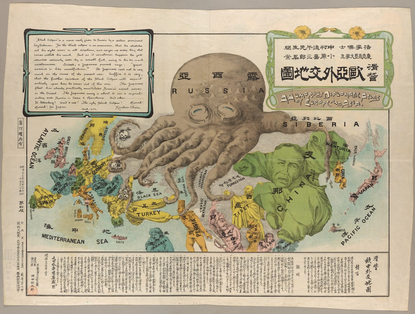
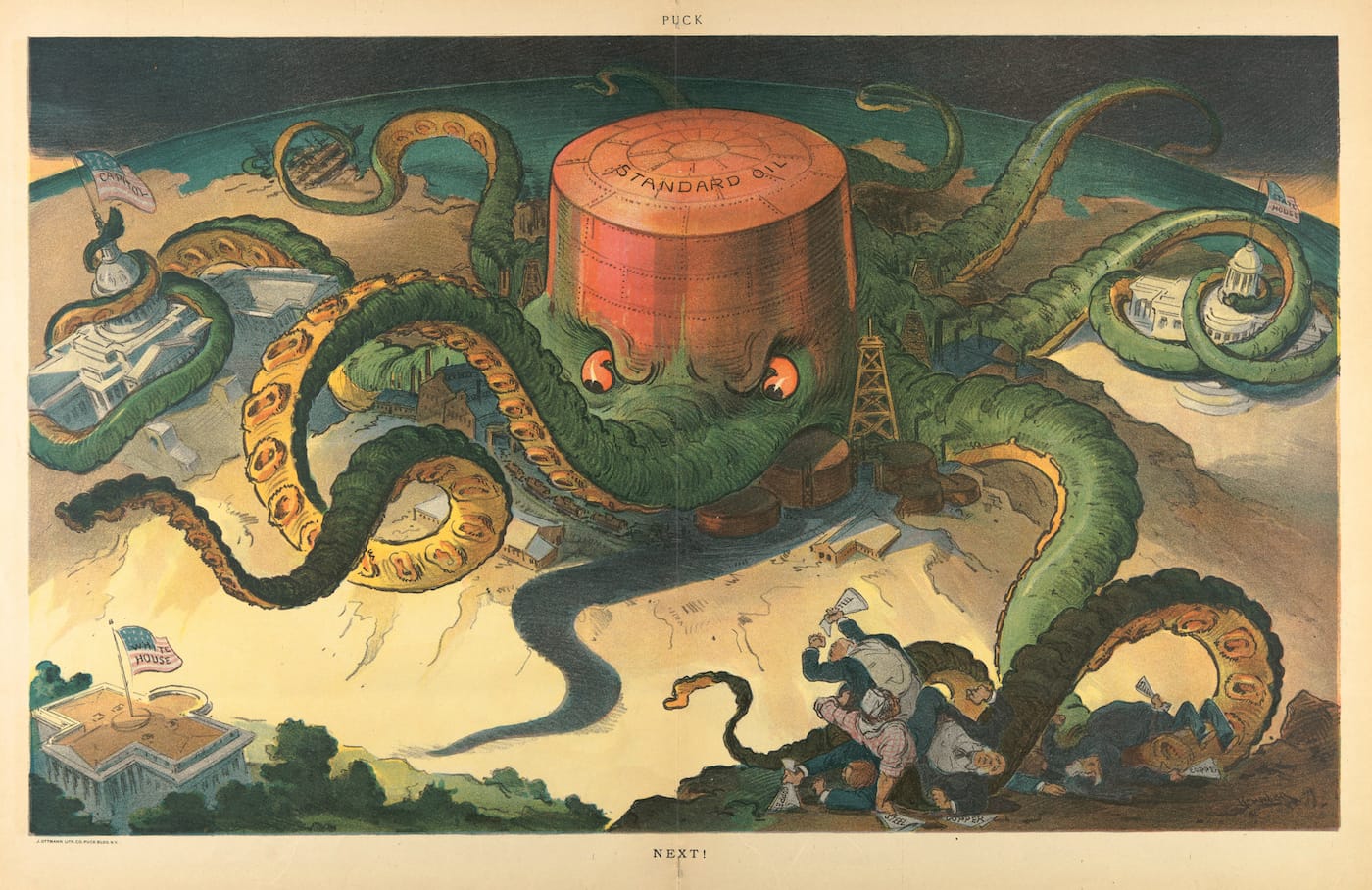
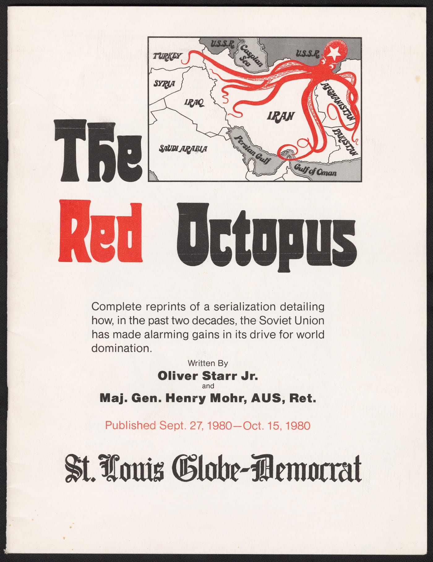
Ashley Baynton-Williams in 2015’s The Curious Map Book, writes that Rose’s map is “the earliest known cartoon map of Russia to portray the country as an octopus” and that the “prevalence of the octopus motif in later maps suggests that the octopus also spoke to humanity’s primeval fears, evoking a terrifying and mysterious creature from the depths.” Later uses include a September 7, 1904, cartoon map in Puck magazine that shows the Standard Oil company strangling American state capitals and Congress, and a 1940s propaganda poster from German-occupied France with Winston Churchill as a grotesque octopus smoking a cigar, his bleeding appendages symbolizing British advances and defeats. Sometimes the map octopus is blubbery, such as on a 1904 anti-Russian map from Japan, where its arms seem to slowly and steadily grow; other times it is thin and agile, like the “red octopus” representing the Soviet Union on a 1980 pamphlet from the St. Louis Globe-Democrat. In all cases, its shape exudes a hungry grasp for power, and some dark, unnatural force that threatens to cover the Earth.
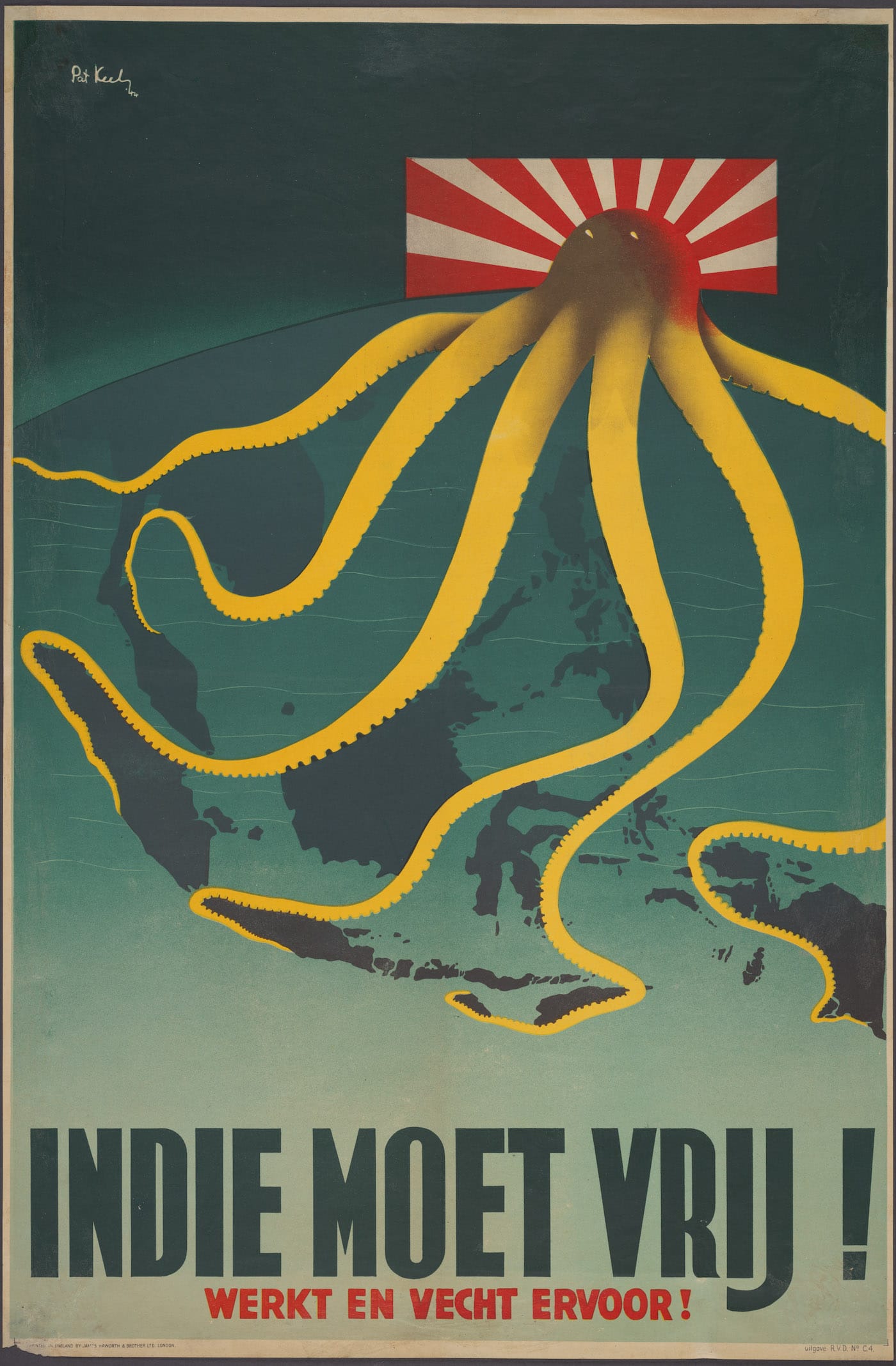
In an article on the “Cartographic Land Octopus” at the Big Think, Frank Jacobs writes that the underwater animal is “a perfect emblem of evil spreading across a map: its ugly head is the centre of a malevolent intelligence, which is manipulating its obscene appendages to bring death and destruction to its surroundings.” In last year’s War Map exhibition at London’s Map House, a copy of a 1944 map that features in the PJ Mode Collection was included. It shows a rising sun transformed into a ravenous octopus emerging from the Japanese flag, its tentacles reaching around the East Indies to cling to the former Dutch Colonies. The image was printed about 10,0000 times for the London-based Netherlands government in exile, the repetition reinforcing the trope as a symbol of threatening invasion.
The octopus actually appeared on maps long before the 19th century, but as the ominous kraken, a sea monster signaling the dangers of the uncharted oceans. Emerged from the waters and dragging its many-armed body over the land, it retains that sense of unease and foreboding.
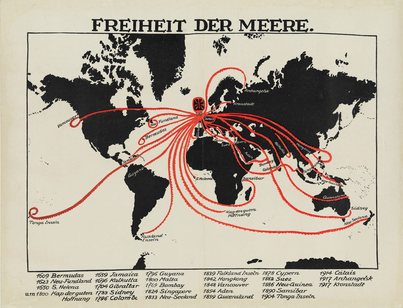
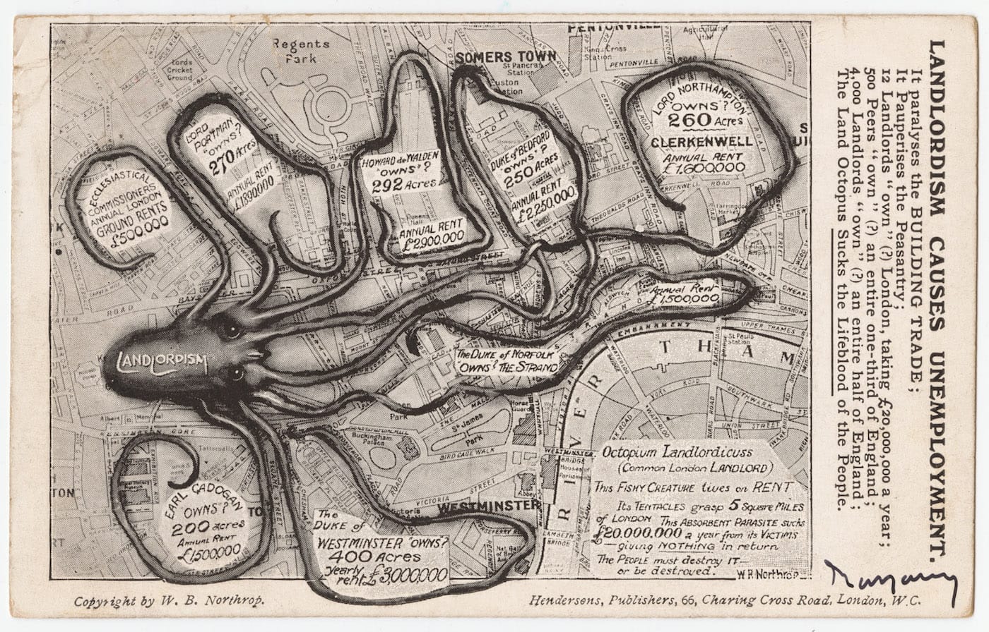
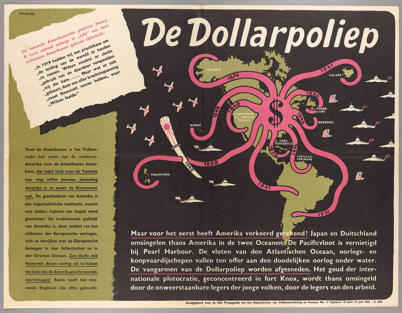
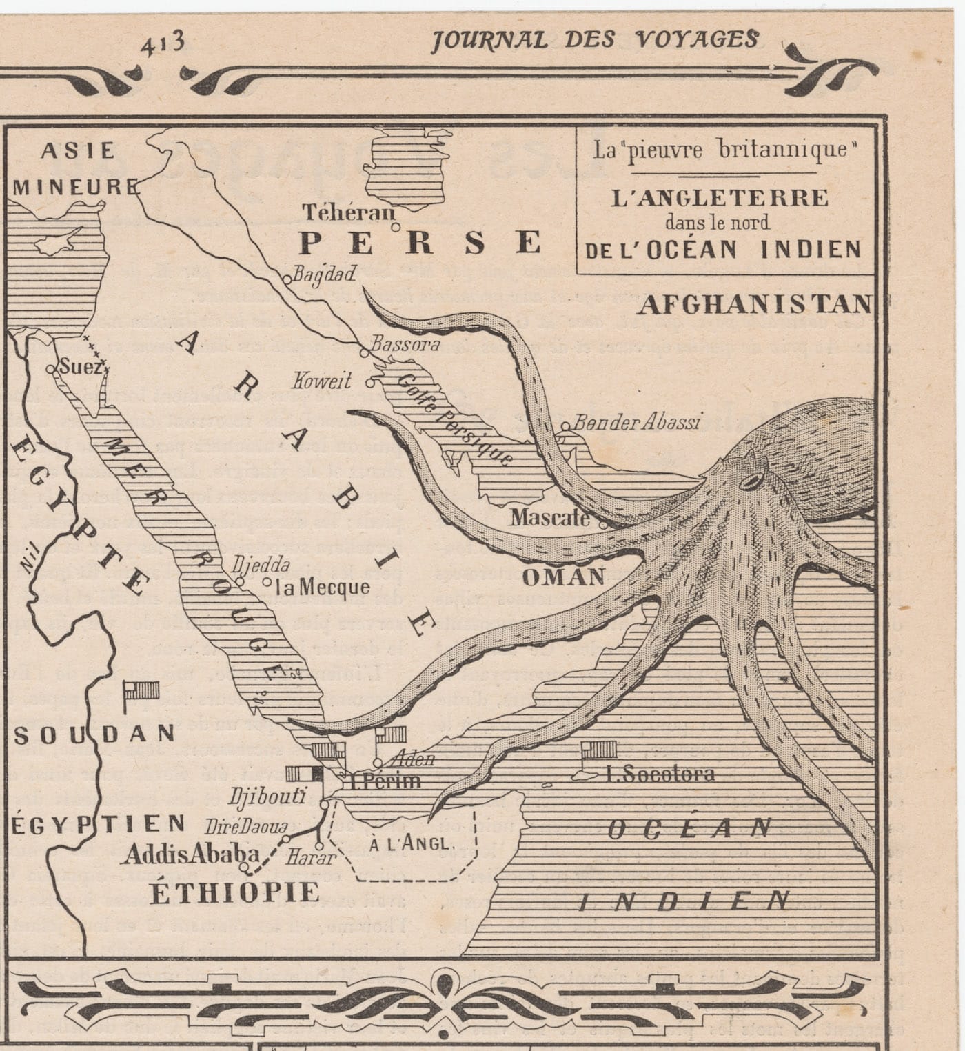
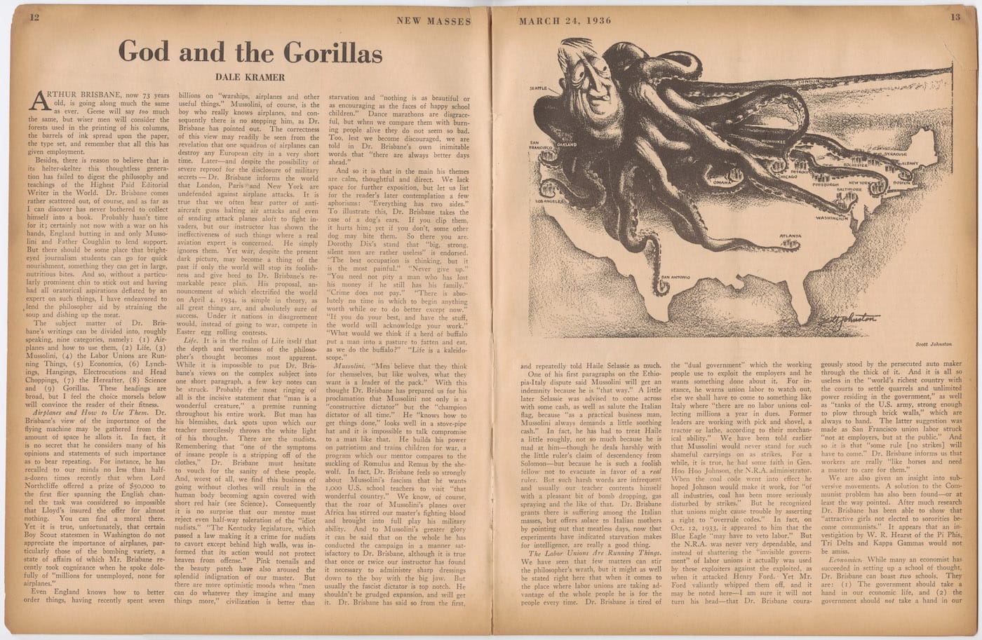
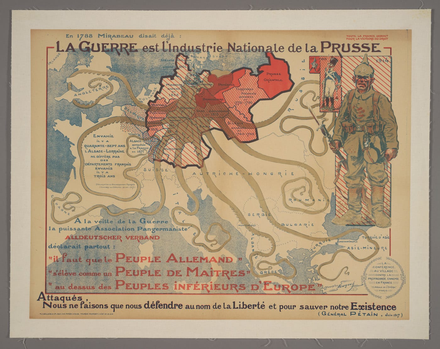
Patrick Cokayne Keely, “Indie Moet Vrij! Werkt en Vecht Ervoor! [The Indies Must Be Free! Work and Fight For It!]” (1944), showing Japan as an octopus with tentacles controlling the Dutch East Indies (courtesy Persuasive Maps: PJ Mode Collection, Cornell University Library)Kisaburō Ohara, “A Humorous Diplomatic Atlas of Europe and Asia” (1904), an anti-Russian map created by a Japanese student at Keio University during the Russo-Japanese War (courtesy Persuasive Maps: PJ Mode Collection, Cornell University Library)Unknown German creator, “Freiheit der Meere [Freedom of the Seas]” (1918), depicting Great Britain as an octopus threatening the “freedom of the seas” with its tentacles reaching to nearly 30 places allegedly colonized or attacked by the British Empire (courtesy Persuasive Maps: PJ Mode Collection, Cornell University Library)W. B. Northrop, “Landlordism Causes Unemployment” (1909), showing the octopus of “Landlordism” strangling London, although the map leaves the royal family’s estates out of its lands owned by the wealthy (courtesy Persuasive Maps: PJ Mode Collection, Cornell University Library)Louis Emile Manche, “De Dollarpoliep [The Dollar Octopus]” (1942), an anti-American propaganda poster created by the Nazis in the Netherlands, showing the United States as an octopus with tentacles encircling the Americas and reaching west into the Pacific and east into the Atlantic (courtesy Persuasive Maps: PJ Mode Collection, Cornell University Library)Nicolas Baladiez, “La ‘pieuvre britannique’ – L’Angleterre dans le nord de l’Ocean Indien [The British Octopus – England in the North Indian Ocean]” (1905), published in Journal des Voyages – Aventures de Terre et de Mer, showing the British Imperial “octopus” reaching to the Arabian peninsula and the horn of Africa (courtesy Persuasive Maps: PJ Mode Collection, Cornell University Library)Joseph Ferdinand Keppler, “Next!,” depicting Standard Oil as an octopus expanding across the United States, strangling state capitals and Congress (1904), published by Puck magazine (courtesy Persuasive Maps: PJ Mode Collection, Cornell University Library)Henry Mohr and Oliver Starr, “The Red Octopus: Complete reprints of a serialization detailing how, in the past two decades, the Soviet Union has made alarming gains in its drive for world domination” (1980), published by St. Louis Globe-Democrat(courtesy Persuasive Maps: PJ Mode Collection, Cornell University Library)Scott Johnson, “God and the Gorillas” (1936), illustrating an article by Dale Kramer for New Masses, with a caricature of Hearst journalist Arthur Brisbane as a giant octopus strangling cities like Seattle and San Antonio (courtesy Persuasive Maps: PJ Mode Collection, Cornell University Library)Maurice Neumont, “La Guerre est l’Industrie Nationale de la Prusse [War is the National Industry of Prussia]” (1917), a French propaganda poster mapping the growth in German armies over two centuries and its territorial expansion (courtesy Persuasive Maps: PJ Mode Collection, Cornell University Library)